There are several ways, how to publish historical documents, such as maps, paintings or books on the institution’s website. This overview is based on our experience with such projects and recommends proven and suitable ways, to deliver the online content to visitors.
Basically, there are only two steps in the process of publishing large imagery online. In the case of publishing maps there are four steps — the result is online maps with geographical position and possible Geographical Search.
High quality for low cost is possible. In the following paragraphs we will go step by step through these four points and introduce open-source tools and their commercial alternatives.
The first step to delivering any online content is hosting. The image has to be stored in a place accessible by users, with a capacity that serves the flow of your visitors. Basically, there are two areas in which you can host images:
Advantage: If you already have the infrastructure and staff that takes care of your server, this solution can be maintained in-house and therefore have a bit lower running cost.
Disadvantage: You need a server (that costs money) and staff that ensures the server is running, updated and in good shape.
IIPImage is a lightweight client-server system for fast and efficient online viewing and zooming of ultra high-resolution images. It is available for free, under an open source license (GNU GPL). We recommend installing the software on a Linux (or other UNIX) server. There is a prepared and easy-to-install binary package for Windows servers.
The format of the files is JPEG2000 and it has been implemented using the Kakadu library redistributable for non-commercial use. Commercial licenses are available as well. If your files are saved in a different format (TIFF, PNG, JPEG, etc.), as a part of the installer there is a utility created by Klokan Technologies that converts your files into JPEG200. Images are accessed via IIIF protocol.
Any standard web hosting (PHP/MySQL) site, where you can host simple HTML files and images, can also host the zoomable maps without any extra configuration. A step-by-step tutorial for the setup is available at OldMapsOnline page.
Advantages: comfortable, outsourced, guaranteed service with no need for own infrastructure or staff. Always up-to date. For clients without their own infrastructure this solution is more cost-effective.
Disadvantages: For clients with their own infrastructure there are higher costs for hosting.
IIIF hosting from Klokan Technologies is a service for stable hosting with support of IIIF protocol, which is a proven solution for the hosting of large imagery daily. It’s used by many of our customers. The prices start at 69 USD for 30GB/month. The images are loaded via FTP, or you can just send us the hard drive and we load them for you. Please contact us for the pricing details.
When step one is finished, the maps are online. To be able to view these online images an online viewer is required. As your files are saved in JPEG2000 format, there are several open-source web viewers that can be used:
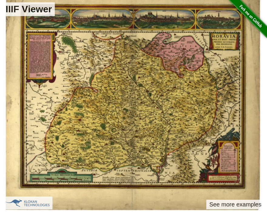
IIIF viewer from Klokan Technologies is optimized for desktop and mobile devices (iOS, Android), is open-source, free to use and has, compared to other viewers, the following extra features:
Demo and source code of IIIF viewer is available on github.
OpenSeadragon is an open-source, Javascript viewer enabling smooth, deep zoom and pan of high-resolution images. OpenSeadragon is IIIF compatible. A demo of OpenSeadragon in action can be seen on the project homepage.
At this point, the images from your collection are online and accessible via the zoomable viewer. This solution is sufficient for non-geographical images, such as paintings, books, manuscripts etc. With infrastructure and open-source tools it is possible to achieve this point without any license or software fees, only your own labor costs. If any step is not clear, Klokan Technologies provides consultation and support services that cover the mentioned topic.
Maps are a bit more specific and need to be processed further. The key is to assign coordinates (latitude x longitude) to your online maps. This topic is covered in the next section.
There are three online tools that can be used to assign a geographical position to your maps:
Free tools from Klokan Technologies, which is widely used by many institutions.
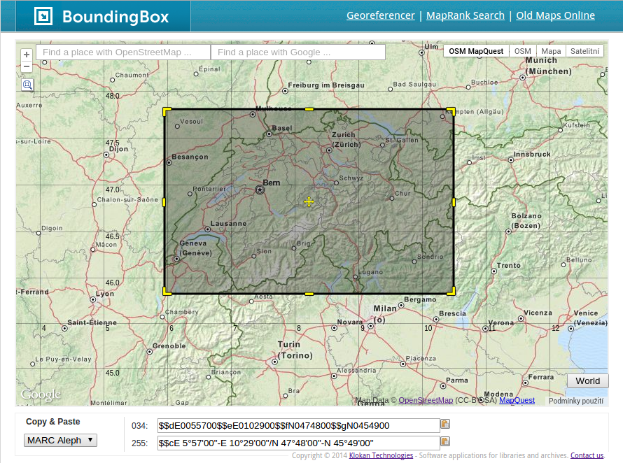
Bounding Box - Drag a rectangle over the location that is covered by the map. Then, copy and paste the coordinates into your library catalog. Supported formats are MARC, DUBLIN CORE, KML, GEOJSON and CSV. This tool is ideal if you have a paper map in hand and need to define the area that it covers.
Geoparser - Calculates the geographical location directly from the catalogue record based on its scale and keywords.
Those tools are free to use and the coordinates you gain can be used for geographical search engines, such as Oldmapsonline.org. However, the results are not that precise and it is not possible to overlay the old maps and study the accuracy. These features are available in the Georeferencer.
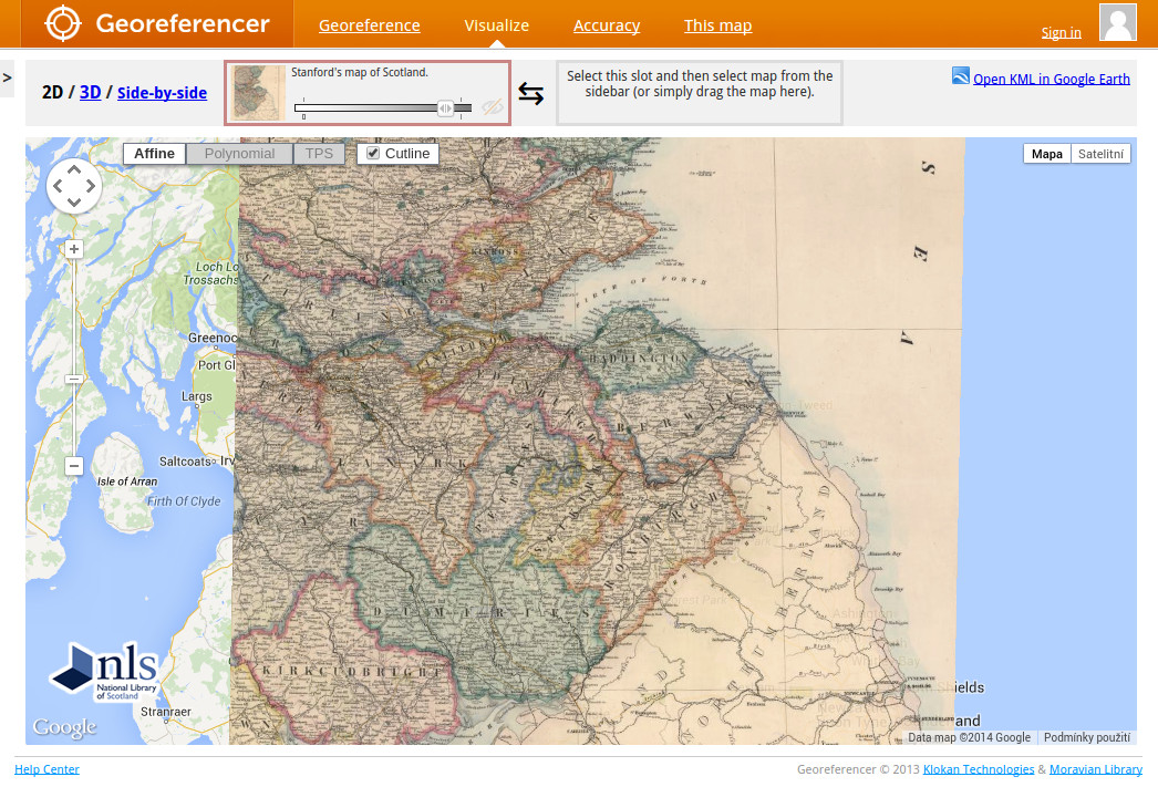
Georeferencer is an online tool that assigns geographical location to any image. The process is very simple — find the same place on both historical and up-to-date maps, click on this place in the left screen and then in the right screen. A minimum of three control points are required to calculate the geographical position of the map. The more control points that are added, the more precise the georeference is. Standardized Web Map Tile Service (OGC WMTS) is delivered immediately.
The historical map can appear as an overlay on the correct position over modern maps or Google Earth. Via crowdsourcing, you can invite visitors of your website or the general public to actively participate and help your institution with the location of your maps. In the successful crowdsourcing projects, hundreds of maps have been georeferenced within days or weeks by the public, with a positive impact on the institution’s likeness.
For more information and pricing, please visit page about Georeferencer.
The last (and recommended, yet not necessary) step is to enable the online search of your maps. There are two ways of how this is possible:
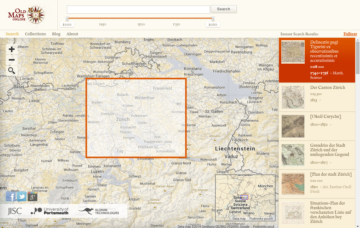
The OldMapsOnline Portal is an easy-to-use gateway to historical maps in libraries around the world.
It allows the user to search for online digital historical maps across numerous different collections via a geographical search. Search by typing a place/name or by clicking in the map window, and narrow by date. The search results provide a direct link to the map image on the website of the host institution.
Joining Oldmapsonline is free, with more information available at: http://project.oldmapsonline.org/contribute
Technology developed by Klokan Technologies that stands behind the OldMapsOnline search portal.
Design can be customized to fit into your website. The results can be further limited to a certain period of time, or any full text phrase and the search is quick as a flash.
For more information and pricing, visit MapRankSearch's website
Thank you for reading this article. Our wish is to see the cultural heritage of maps and historical documents online. We are here to help you, as developers providing the tools for online map publishing and their adjustments, and also as consultants, to assist you with the deployment of any mentioned tools. For any questions do not hesitate to contact us.